
Part 1: American Brewers' Review 1898 Brewers' Guide
This is the first of four articles that focus on the American Brewers' Review 1898 Brewers' Guide.
Introduction: American Brewers' Review 1898 Brewers' Guide
Part 2. A discussion of the types of beer brewed in 1898
Part 3. A brief discussion of bottling, malting and more about Germans
Part 4: Germans in the brewing industry in 1898
Detailed comparative statistics for 19th century breweries have been difficult for me to find. The major contemporary work on the subject is American Breweries II published by Dale P. Van Wieren in 1995. American Breweries II (AB2) is an update of The Register of American Breweries 1876-1976 published by Manfred Friedrich and Donald Bull in 1976. Since the publication of AB2, its’ directory data has been passed on to the American Brewerania Association which maintains it as a live database. This lineage of directories is designed for collectors of brewery memorabilia. It is not, as useful, for someone like me who wants data points like; production quantities, size of facilities, architectural styles, spatial arrangements, ethnicity of ownership, etc. The AB2 data is still very useful though. The AB2 directory intends to include every brewery that ever operated in the United States. Each entry in AB2 includes the brewery name and the name of the owner or operator. Entries are organized by city and state. Many entries have some locational information. AB2 does not include information about what types or quantities of beer were made. All brewery entries in AB2 are given a two letter state abbreviation and a serialized number. I have adopted this coding system for my own database. I digitized the AB2 entries for pre-1919 breweries by cutting off the spine of the book with my table saw, scanning the pages, and painstakingly converting some of the information from the resulting PDF into a table. I then geocoded the brewery entries to city centers.
The US Census is another good source of statistical information about breweries. The Census of the late 1900s had production data but that and other data points are at state level or in some years aggregated for select cities and metropolitan areas. This is useful but not helpful for mapping using units smaller than states. The source of the most useful information I’ve found so far is the United States’ Brewers Association (USBA). The USBA was established in 1862 as a direct response to a beer tax which was established to fund the Civil War. That beer tax, which was $1 per barrel, was from the 1860s to 1919, the origin of almost all reliable statistical information about breweries. The USBA was initially an all-German organization but began inviting non-Germans shortly after its’ founding. The organization grew rapidly as the brewing industry industrialized. By the 1880s, the USBA was publishing annual convention notes with brewing industry statistics. Since membership dues were based on production, the production levels of individual breweries can be deduced from the organization financial information published in the convention yearbooks. Those production levels can only be deduced for member brewers though. And the USBA stopped this practice in the late 1890s. The USBA had an associated journal, The American Brewers Review, which was published from the 1890s into the 1910s. The USBA also published several useful books. One of those books, Beer, Its History and Its Economic Value, contains a census of some 2,400 breweries including production figures and many addresses for the years 1878 and 1879.
The American Brewers’ Review briefly included a directory of breweries in the United States in the 1890s. Two of these have been digitized by the New York Public Library and are available for free here. The 1896 directory is missing two pages. The 1898 directory appears to be complete though. I recently added both to my growing geographical database of pre-prohibition breweries. The geographical database I’ve been working on also includes all breweries mentioned in AB2 that operated prior to national prohibition, the 1878 and 1879 census mentioned above, and a large amount of information I’ve gathered from fire insurance atlases and site visits. Most of these 8,000 breweries are mapped to arbitrary centers of the cities they were located in. Around 1,000 are mapped to specific locations in cities were the breweries stood or still stand. Each brewery/row in the database has a AB2 style key so new information can be joined to the existing data with relative ease. The 1898 Brewers’ Guide had listings for 1,720 breweries. Each brewery entry in the Brewers’ Guide is followed by codes indicating the amount of production given in a range, and the type of beer produced, whether lager, porter or ale. The codes also indicate whether the brewery was producing its’ own malt.
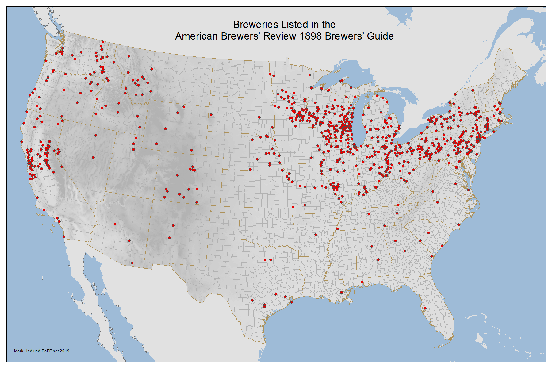
Click Image for Larger Map
There are several things that I think are interesting about the simple map above. The South has almost no breweries. The Missouri river system can be seen clearly west of St. Louis into Nebraska. The mining districts that were active at the time are visible including the Motherlode, the Anthracite district, the Butte area, and others. The connection between beer brewing and other types of industrial production is clear in this map. There is one glaring exception to that though and that is in the agricultural lands of Wisconsin and Minnesota. There were 145 breweries in Wisconsin that were outside of Milwaukee. This is an exception to the normal clustering of breweries in major industrial cities. Most of the small town breweries in Wisconsin produced less than 1,000 barrels per year.
Comparing the information in the 1896 directory to the 1898 directory leads me to believe that the coded information is sometimes inaccurate, especially in regards to the smaller establishments. But aggregated information matches other sources so I estimate that these directories are as accurate, on average, as any other source on the subject.
USBA 1898 |
1898 Brewers' Guide |
American Breweries II 1898 |
US Census 1900 |
|
US Total Production |
37493306 |
38581750 |
||
US Total Establishments |
1845 |
1720 |
1876 |
1507 |
Establishments |
||||
New York |
288 |
264 |
282 |
225 |
Pennsylvania |
246 |
219 |
240 |
208 |
Illinois |
126 |
123 |
129 |
94 |
Ohio |
142 |
123 |
129 |
111 |
Wisconsin |
175 |
164 |
169 |
147 |
Missouri |
54 |
51 |
58 |
49 |
New Jersey |
52 |
48 |
58 |
44 |
Massachusetts |
56 |
37 |
49 |
40 |
California |
138 |
124 |
123 |
99 |
Michigan |
92 |
87 |
97 |
77 |
Production |
||||
New York |
10093450 |
10670750 |
||
Pennsylvania |
4245972 |
4116750 |
||
Illinois |
3601163 |
3767750 |
||
Ohio |
2886830 |
3115750 |
||
Wisconsin |
2886502 |
3012500 |
||
Missouri |
2435700 |
2484500 |
||
New Jersey |
2110310 |
2135750 |
||
Massachusetts |
1805508 |
1740000 |
||
California |
797350 |
823500 |
||
Michigan |
792647 |
780000 |
The production data in the Brewers' Guide is coded in ranges. For example, breweries producing between 400,000 and 500,000 barrels annually are given the code “A 6”. I interpreted these ranges as midpoints, or in this example: ”A 6” = 450,000, for the sake of convenience. There are 48 possible production ranges that I converted to numeric values with Python. In spite of this averaging, the production totals match fairly closely the data from the USBA which would have been derived from tax rolls. It does seem that production totals are inflated in states that have more small breweries. This is probably because the average production of breweries coded “E 6”, the smallest range, was less than 250 barrels per year, the midpoint of that range. The USBA is my only other source of state specific production totals. In number of breweries, the 1898 Brewers’ Guide falls between the AB2, USBA data and the Census. The AB2 numbers are derived from selections of the entire pre-prohibition part of the AB2 data set. Massachusetts is the only state where there is a significant difference. The USBA number of breweries might be higher due to persons receiving brewing licenses without actually producing beer. The American Breweries II number might be higher due to double entries and inaccurate open and closing years for some breweries. Generally though, the data is probably good enough for this study.
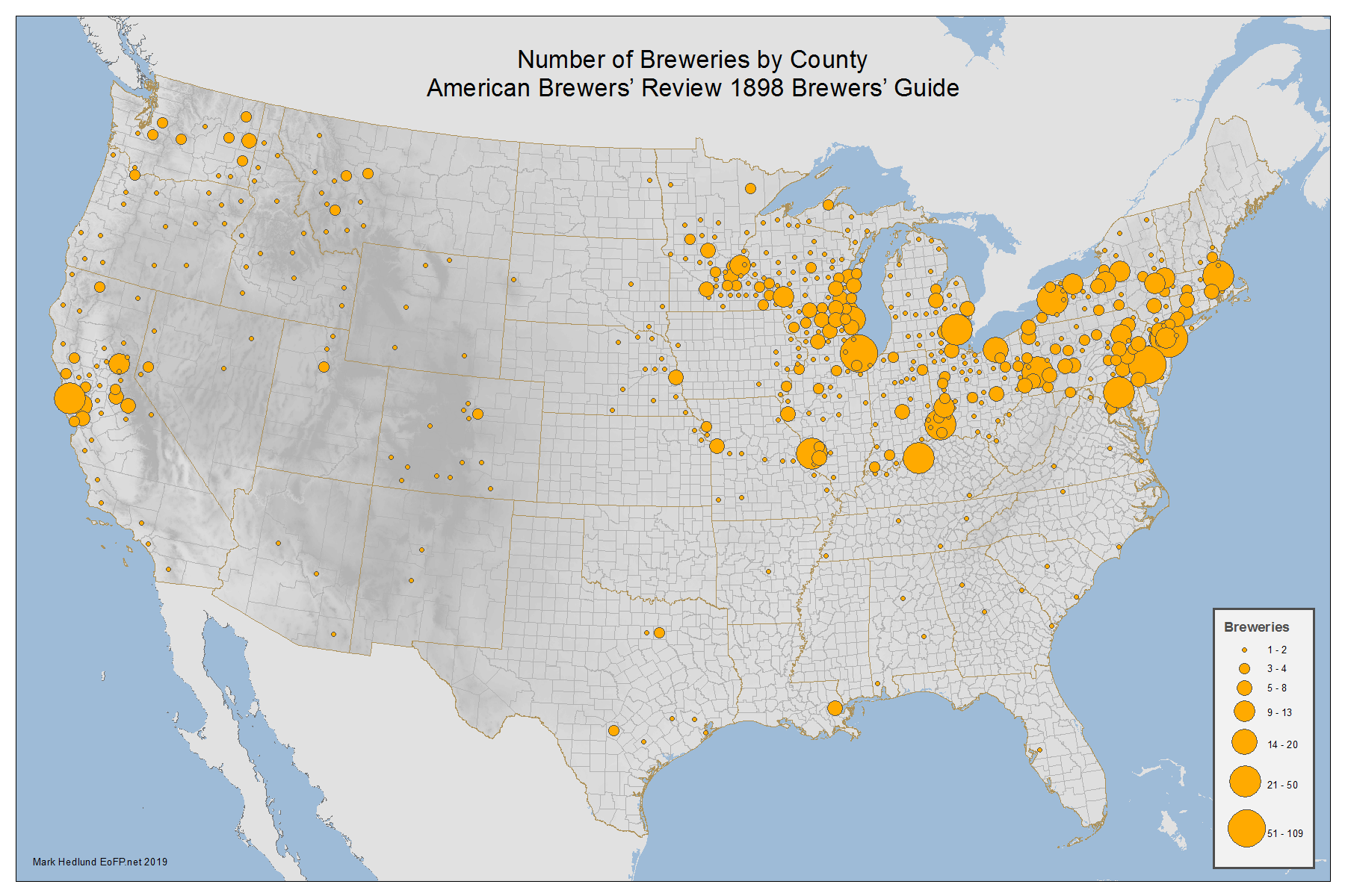
Click Image for Larger Map
The number of breweries in each county can be easily totaled with a spatial join in ArcMap. A spatial join adds the attributes of all points, each point being a brewery in this case, that exist within the boundaries of a shape to that shape. Shapes in this instance are county boundaries. This process can also give the total amount of production for all the breweries in a given county. This is a convenient way of aggregating data because it relies on the fixed locations of breweries relative to arbitrary boundaries. The boundaries of many cities and counties have changed since 1898. In the above map the five counties of New York City have been merged into one. Aggregating at the county level gives some visual weight to each brewery rather than hiding points behind points in crowded areas. The above map gives a better sense of the clustering of breweries in large cities.
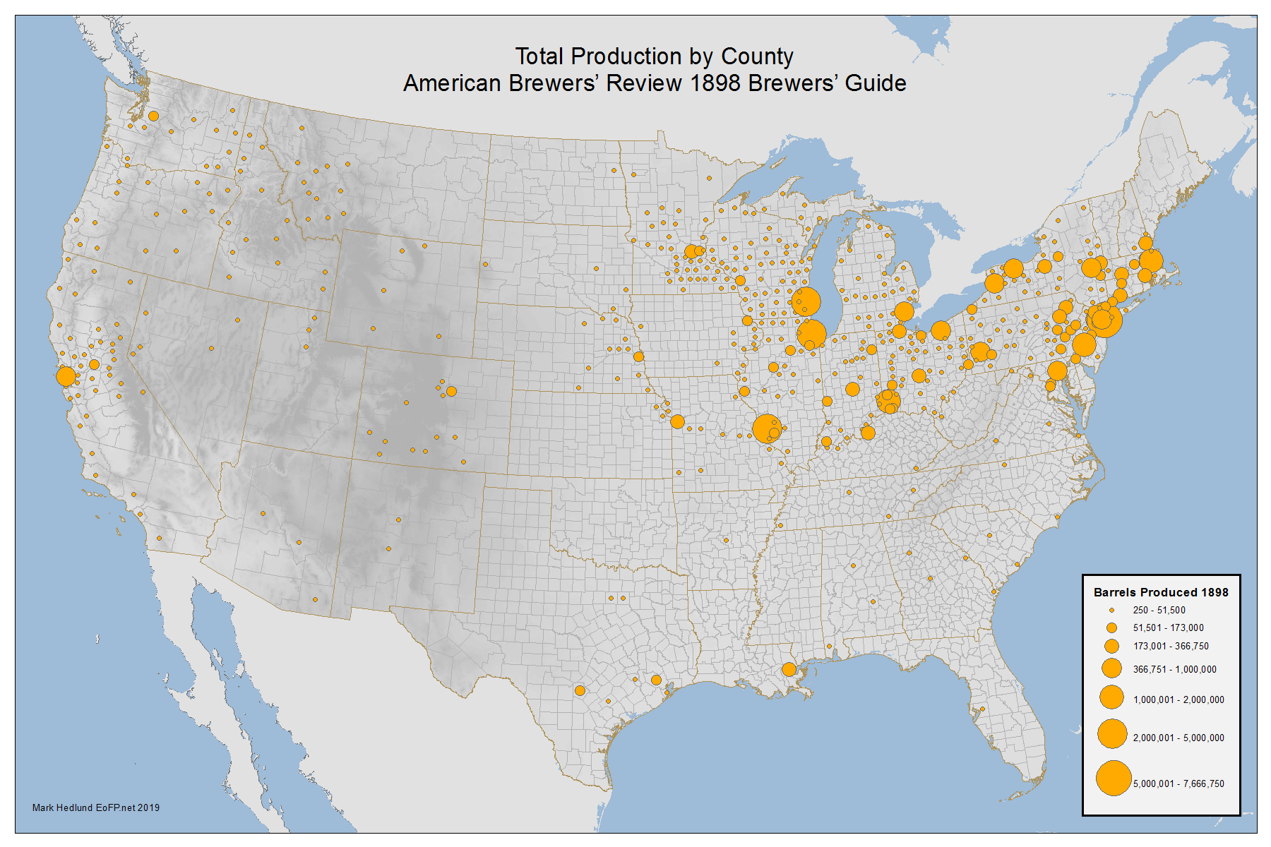
Click Image for Larger Map
When the map is symbolized by barrels produced rather than number of breweries, a different picture emerges. The major brewing centers of the Midwest and the Northeast are clearly visible above. Counties without industrial scale breweries fade into the background. But the map above still obscures the dominance of New York State and New York City in the turn of the century brewing industry. The academic literature of the 19th century brewing industry is often focused on the brewing centers of the Midwest. This is understandable as the brewing companies that dominated the market in the second half of the 20th century all arose there. But in 1898, more beer was produced in New York State than in Missouri, Wisconsin and Ohio combined. 7,560,500 barrels were produced in New York City alone. That was more than twice the amount produced in Wisconsin that year - 2,886,502 barrels. The total production of the 153 breweries in the larger New York Metropolitan area was 9,778,500 barrels. Further aggregating production of counties in metropolitan areas produces the map below.
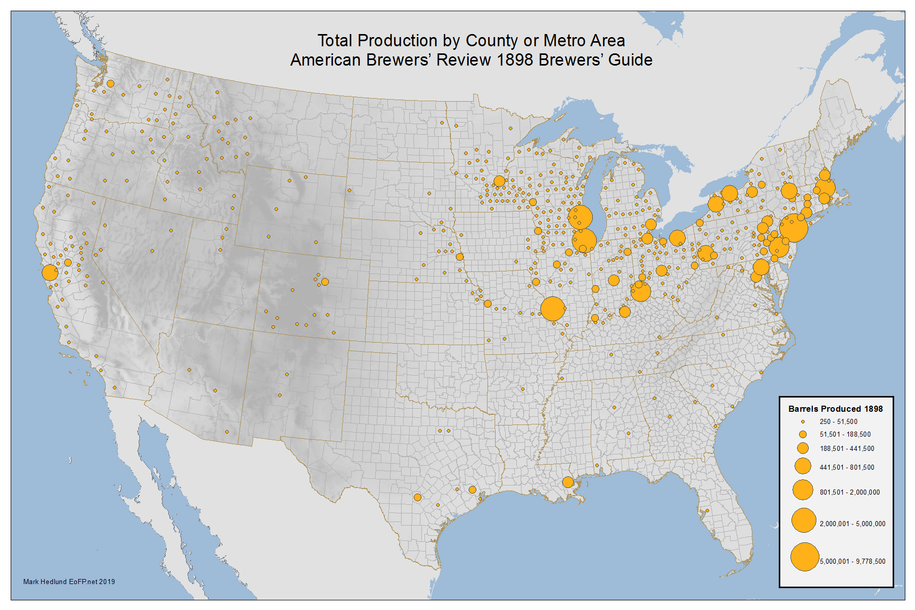
Click Image for Larger Map
Part 2. A discussion of the types of beer brewed in 1898
All content on these pages Copyright Mark Hedlund 2012-2019. All rights reserved. Use in school projects and with links on social media is always okay. Please send me an email to request permission for any other use: hedlunch@yahoo.com Non-exclusive commercial publication rights for most photos is $25 per image.